Hurricane Humberto strengthens to Category 3 while approaching Bermuda
Thursday, September 19, 2019
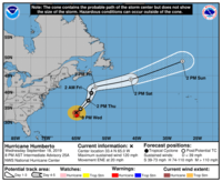
In an advisory issued yesterday evening, the National Hurricane Center (NHC) confirmed that a hurricane warning for Hurricane Humberto, a category 3 hurricane, was in effect for Bermuda. Humberto was expected to pass by Bermuda late Wednesday night.
The NHC's "Hurricane Humberto Intermediate Advisory Number 25A", released at 8:00 p.m. AST on Wednesday (0000 UTC Thursday morning) placed Humberto 75 miles (120 kilometers) north of Bermuda. At the time, Humberto had maximum sustained winds of 120 miles per hour (195 kilometers per hour) and was moving east-by-northeast at 20 mph (31 kph).
The NHC predicted that Humberto would pass by Bermuda Wednesday night, before beginning to weaken on Thursday. The advisory also noted dangerous surf conditions, with waves over 30 feet high being recorded offshore by a National Oceanic and Atmospheric Administration (NOAA) buoy, warning of a possibility of coastal flooding.
Bermuda was rarely hit by hurricanes according to CNN who reported that over the last century, only 21 hurricanes reached within 100 miles of the islands. The most recent hurricane to reach Bermuda, Hurricane Gonzalo, made landfall there in 2014.
Hurricanes are a form of tropical cyclones. On the Saffir–Simpson scale used by the NHC for classifying tropical cyclones, a category 3 hurricane must sustain winds of at least 111 miles per hour. The cut-off for a category 4 hurricane, the next stronger classification, is 130 mph. Hurricanes classified as category 3 or above are considered to be "major" hurricanes.
Related news
- "Tropical Storm Humberto upgraded to hurricane status" — Wikinews, September 16, 2019
Sources
- "Saffir-Simpson Hurricane Wind Scale" — National Hurricane Center, September 19, 2019 [date of access]
- "Hurricane Humberto Intermediate Advisory Number 25A" — National Hurricane Center, September 18, 2019
- Michelle Krupa, Judson Jones and Christina Maxouris. "Hurricane Humberto's swipe at Bermuda leaves 80% of island without power" — CNN, September 18, 2019


