Icelandic volcanic eruption prompts evacuation, flight diversions
Sunday, March 21, 2010
A volcanic eruption started yesterday in south Iceland at or near the Eyjafjallajökull glacier. The first signs of the eruption were seen between 23:00 and midnight GMT. It is still not clear where the exact location of the eruption is but it appears to be on Fimmvörðuháls.

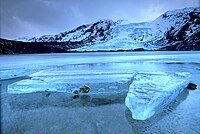
Image: Andreas Tille.
People living in the area are being evacuated. Police have closed the roads into the area and a state of emergency has been declared. The eruption is expected to result in flooding if it is under the glacier, but fortunately it appears to between Eyjafjallajökull and another glacier, Mýrdalsjökull, reducing the danger of flooding. It is reported that the eruption can be seen as far away as from Vestmannaeyjar. So far the lava flow is viscous and thick.
There is also a danger that this eruption could trigger another eruption on nearby Mt. Katla, which is an off-rift volcano beneath Mýrdalsjökull. In the past, eruptions at Eyjafjallajökull have triggered eruptions at Mt. Katla. If Katla does erupt, the effect would be far more significant than that of the current eruption, as lava could melt the ice at the top of the mountain, causing the potential for massive flooding.
The air carrier Icelandair has diverted flights which were destined for Iceland as a precaution, due to the risks to aircraft of flying into volcanic ash. A notice to airlines prohibits flights within 120 nautical miles of the volcano.
Iceland is a volcanic island situated atop the Mid-Atlantic Ridge at the juncture of the North American and Eurasian tectonic plates.
Sources
- "Eldgosið við Eyjafjallajökul 2010" — March 21, 2010 (Icelandic)
- "Eldgos hafið í Eyjafjallajökli" — RÚV, March 21, 2010 (Icelandic)
- Haukur S. Magnússon. "Volcano Erupts Under Eyjafjallajökull" — The Reykjavík Grapevine, March 21, 2010
- "Volcanic eruption in Eyjafjallaglacier - flights to Iceland are on hold" — Icelandair, March 21, 2010
- "Volcano erupts near Eyjafjallajokull in south Iceland" — BBC News Online, March 21, 2010
- Smithsonian National Museum of Natural History. "Eyjafjöll" — Global Volcanism Program, March 21, 2010
- Flugstoðir. "A-NOTAM no. A0085/10 ERUPTION - EYJAFJOLL" — March 21, 2010
- National Commissioner of the Icelandic Police, Civil Protection Department. "News in English: Eruption in Eyjafjallajökull glacier" — March 21, 2010
- "Volcano erupts in Iceland, hundreds flee" — Alertnet, March 21, 2010
