File:Scottish counties flood damage July 24 2007.png

Size of this preview: 524 × 599 pixels. Other resolutions: 210 × 240 pixels | 420 × 480 pixels | 672 × 768 pixels | 895 × 1,024 pixels | 1,616 × 1,848 pixels.
Original file (1,616 × 1,848 pixels, file size: 123 KB, MIME type: image/png)
| This free media file is from Wikimedia Commons. Its description page is included below. |
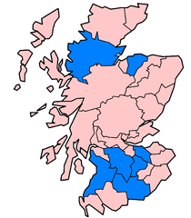
| Description | There are several possible subdivisions of Scotland to choose from: pre-1890 counties, 1890-1975 counties, 1975-1996 regions and districts, 1996 council areas, Scottish Parliament constituencies, et al. I have chosen the 1890 counties because a) the pre-1890 counties had exclaves, b) the 1975 region and districts are too big, c) the 1996 council areas and the Scottish Parliament constituencies have a wide disparity in sizes and using them would have distorted the situation. The 1890 counties are still understood, used by the BBC, almost identical to the registration counties and mapping the flood damage onto these borders produces a result that's close to the truth. The 1890 counties affected by flooding on/by July 24th 2007 are Ayrshire (Kilmarnock and Newmilns), Dumfriesshire (various), Lanarkshire (Glasgow and areas south), Peebles, Midlothian (Edinburgh), Moray (Rothes to Aberlour) and Ross&Cromarty (Strathcarron and Achnasheen). Every effort has been made to reduce error, and I apologise for any errors/omissions. Some areas with only minor damage have been omitted. To forestall criticism, citations for each and every one of these areas can be found on http://en.wikipedia.org/w/index.php?title=2007_United_Kingdom_floods&oldid=148443176 under "Affected areas in Scotland". | ||||||||
| Date | |||||||||
| Source | This image was created by me in Microsoft Paint (don't laugh) on 2007-07-28 using http://en.wikipedia.org/wiki/Image:ScotlandCountiesBlank.png by User:Morwen as a template (that template has on 2007-07-28 the same GFDL license as this image) and updated by me in Microsoft Paint on 2007-08-01. | ||||||||
| Author | Anameofmyveryown | ||||||||
| Permission (Reusing this file) |
|

File history
Click on a date/time to view the file as it appeared at that time.
| Date/Time | Thumbnail | Dimensions | User | Comment | |
|---|---|---|---|---|---|
| current | 01:21, 18 September 2007 | | 1,616 × 1,848 (123 KB) | Anameofmyveryown | {{Information |Description=There are several possible subdivisions of Scotland to choose from: pre-1890 counties, 1890-1975 counties, 1975-1996 regions and districts, 1996 council areas, Scottish Parliament constituencies, et al. I have chosen the 1890 co |
File usage
The following page uses this file:
Global file usage
The following other wikis use this file:
- Usage on en.wikipedia.org