File:Republic of Lakota Map.jpg
Republic_of_Lakota_Map.jpg (325 × 273 pixels, file size: 24 KB, MIME type: image/jpeg)
Summary edit
| Description |
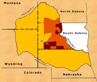
Map of the Republic of Lakotah. Gold area: Lakota Nation Reserved by the 1868 Treaty for the unreserved use of the Lakota people. Orange: 1876 Lakota reservation after the US stole the Black Hills. Maroon: Lakota reservations after 100 years of court actions. |
|---|---|
| Source | |
| Date |
January 5, 2008 |
| Credit |
Lakota Freedom Delegation/Republic of Lakota |
| Permission |
See below |
Fair-Use Rationale: This map is used in the article: Lakota Freedom Delegation says spokesman 'hijacked' organization. Any use elsewhere would have its own rationale. The image is of lower resolution than available at the source. There is currently no free alternative image/map, however it is technically possible to create a free alternative. It has been explicity stated by the source that the image has been released for use in media, such as news-reporting.
License edit
|
| This work is copyrighted. The individual who uploaded this work and first used it in an article, and subsequent persons who place it into articles assert that this qualifies as fair use of the material under United States copyright law. This work has been released for use in news and editorials. If this image is of a living person, it should not be used without first making an effort to find a free alternative (try Wikimedia Commons or Creative Commons). Should you find and upload a free alternative to Wikimedia Commons, please label this image as {{Deprecated image|replacement=<image>|date=Month Dayno, Year}} This template must be accompanied by a source, information on the copyright owner, and a fair-use rationale for every use, as described in our policies regarding non-free media. Media which does not contain this information may be deleted. |
File history
Click on a date/time to view the file as it appeared at that time.
| Date/Time | Thumbnail | Dimensions | User | Comment | |
|---|---|---|---|---|---|
| current | 09:09, 5 January 2008 |  | 325 × 273 (24 KB) | DragonFire1024 (talk | contribs) | {{Image info| |Caption=Map of the ''Republic of Lakotah. Gold area indicates boundaries that could be taken back if all treaties with the Lakota People and the United States are withdrawn. Red and maroon a |
You cannot overwrite this file.
File usage
The following page uses this file:
