File:Location of Thai Binh within Vietnam.png
No higher resolution available.
Location_of_Thai_Binh_within_Vietnam.png (200 × 333 pixels, file size: 33 KB, MIME type: image/png)
| This free media file is from Wikimedia Commons. Its description page is included below. |
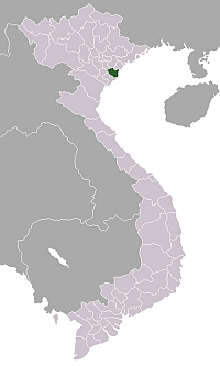
Map locating Thai Binh province in Vietnam. Made for Wikipedia by uploader.

|
Permission is granted to copy, distribute and/or modify this document under the terms of the GNU Free Documentation License, Version 1.2 or any later version published by the Free Software Foundation; with no Invariant Sections, no Front-Cover Texts, and no Back-Cover Texts. A copy of the license is included in the section entitled GNU Free Documentation License. |
| This file is licensed under the Creative Commons Attribution-Share Alike 3.0 Unported license. | ||
| ||
| This licensing tag was added to this file as part of the GFDL licensing update. |
File history
Click on a date/time to view the file as it appeared at that time.
| Date/Time | Thumbnail | Dimensions | User | Comment | |
|---|---|---|---|---|---|
| current | 22:35, 20 January 2006 | | 200 × 333 (33 KB) | Vardion | correcting boundary between Dien Bien and Lai Chau provinces |
| 21:26, 15 June 2005 |  | 200 × 333 (33 KB) | Vardion | Map locating Tinh Binh province in Vietnam. Made for Wikipedia by uploader. {{GFDL}} |
File usage
No pages on the English Wikinews link to this file. Pages on other Wikimedia projects are not listed here.
Global file usage
The following other wikis use this file:
- Usage on ar.wikipedia.org
- Usage on bg.wikipedia.org
- Usage on ca.wikipedia.org
- Usage on de.wikipedia.org
- Usage on de.wikivoyage.org
- Usage on diq.wikipedia.org
- Usage on en.wikipedia.org
- Usage on es.wikipedia.org
- Usage on fi.wikipedia.org
- Usage on fr.wikipedia.org
- Usage on id.wikipedia.org
- Usage on it.wikipedia.org
- Usage on pam.wikipedia.org
- Usage on pt.wikipedia.org
- Usage on ru.wikipedia.org
- Usage on sr.wikipedia.org
- Usage on sv.wikipedia.org
- Usage on tg.wikipedia.org
- Usage on uk.wikipedia.org
- Usage on war.wikipedia.org
- Usage on www.wikidata.org