File:Gaza Strip-CIA WFB Map.png
No higher resolution available.
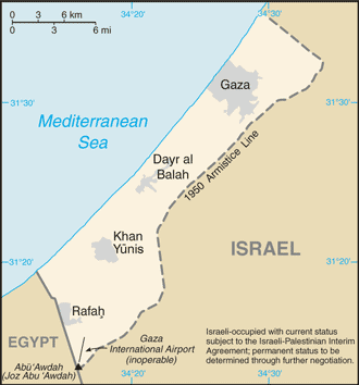
Gaza_Strip-CIA_WFB_Map.png (330 × 354 pixels, file size: 13 KB, MIME type: image/png)
| This free media file is from Wikimedia Commons. Its description page is included below. |
- See also the 2004 version.
.png)
This image is in the public domain because it contains materials that originally came from the United States Central Intelligence Agency's World Factbook.
|
 |
File history
Click on a date/time to view the file as it appeared at that time.
| Date/Time | Thumbnail | Dimensions | User | Comment | |
|---|---|---|---|---|---|
| current | 05:36, 21 July 2007 | | 330 × 354 (13 KB) | Hoshie | Updated map of the Gaza Strip from the CIA World Factbook, 14 June 07 rev. Src: https://www.cia.gov/library/publications/the-world-factbook/maps/gz-map.gif |
| 10:25, 21 January 2006 |  | 329 × 353 (9 KB) | Hoshie | Updated map from the World Factbook, 10 Jan 06 rev. http://www.cia.gov/cia/publications/factbook/geos/gz.html | |
| 09:14, 27 March 2005 |  | 328 × 352 (8 KB) | Wolfman~commonswiki | {{CIA-map}} |
File usage
The following 2 pages use this file:
Global file usage
The following other wikis use this file:
- Usage on de.wiktionary.org
- Usage on en.wikisource.org
- Usage on hu.wikipedia.org