File:Filchner-ronne-schelfeis.jpg
Size of this preview: 463 × 599 pixels. Other resolutions: 185 × 240 pixels | 371 × 480 pixels | 850 × 1,100 pixels.
Original file (850 × 1,100 pixels, file size: 81 KB, MIME type: image/jpeg)
| This free media file is from Wikimedia Commons. Its description page is included below. |
Summary
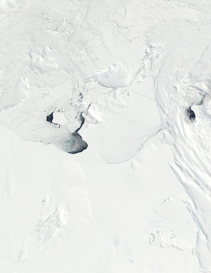
| Description | This true-color image from the MODIS on NASA’s Terra satellite shows a portion of the West Antarctic coastline from about 60 degrees West (left) to about 20 degrees West (right). The image span (left to right) The Ronne Ice Shelf and Filchner Ice Shelf (the two are separated by Berkner Island, whose outline is barely visible just left of the center of the image), and Coats Land. At bottom right, a few rocky peaks are visible through the snow, and are known as the Shackleton Range. |
| Date | |
| Source |
http://visibleearth.nasa.gov/view_rec.php?id=3851
|
| Author | NASA |
Licensing
| This file is in the public domain in the United States because it was solely created by NASA. NASA copyright policy states that "NASA material is not protected by copyright unless noted". (See Template:PD-USGov, NASA copyright policy page or JPL Image Use Policy.) | ||
 |
Warnings:
|
File history
Click on a date/time to view the file as it appeared at that time.
| Date/Time | Thumbnail | Dimensions | User | Comment | |
|---|---|---|---|---|---|
| current | 05:25, 22 December 2005 | | 850 × 1,100 (81 KB) | Saperaud~commonswiki | *'''Description:''' Ronne-Filchner-Schelfeis *'''Source:''' http://visibleearth.nasa.gov/cgi-bin/viewrecord?19900 / German Wikipedia, original upload 26. Jun 2004 by Jensflorian [[de:Bild:{{subst:PAGENAME}}]] {{PD-USGov-NOAA} |
File usage
The following page uses this file:
Global file usage
The following other wikis use this file:
- Usage on ar.wikipedia.org
- Usage on ast.wikipedia.org
- Usage on bg.wikipedia.org
- Usage on ca.wikipedia.org
- Usage on de.wikipedia.org
- Usage on es.wikipedia.org
- Usage on ka.wikipedia.org
- Usage on lv.wikipedia.org
- Usage on ru.wikipedia.org
- Usage on sv.wikipedia.org
- Usage on tr.wikipedia.org
- Usage on www.wikidata.org