File:Cimaron 2006-10-29 0500Z (cropped).jpg

Original file (6,000 × 6,000 pixels, file size: 4.18 MB, MIME type: image/jpeg)
| This free media file is from Wikimedia Commons. Its description page is included below. |
Summary
| Description |
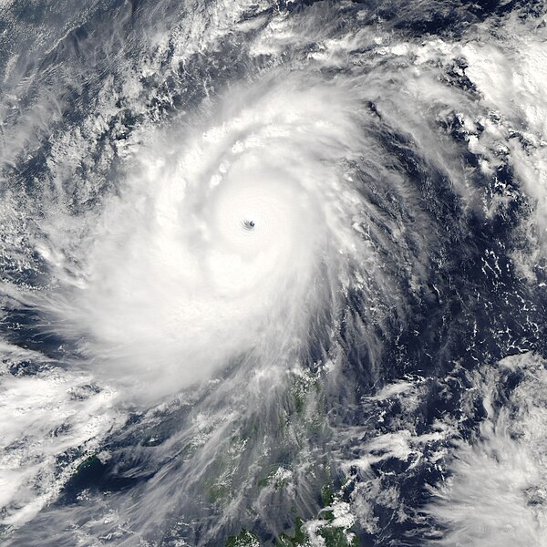
Super Typhoon Cimaron struck the northernmost large island in the Philippines, Luzon, on October 29, 2006. According to BBC News Service, the typhoon was the most powerful to strike the island chain since 1998, lashing Luzon with 200-kilometer-an-hour (125-mile-per-hour) winds and torrential rain. As of October 30, 13 deaths directly attributable to the storm had been reported. This photo-like image was acquired by the Moderate Resolution Imaging Spectroradiometer (MODIS) on the Aqua satellite on October 29, 2006, at 1:00 p.m. local time (5:00 UTC). Super Typhoon Cimaron was a tightly wound ball of clouds just hours from landfall on Luzon. Winds were around 255 kilometers per hour (160 miles per hour) at the time of this image, according to Weather Underground’s Hurricane Archive. As the storm came ashore, it eased off these Category 5-strength winds, but it still struck the mountainous islands with Category 4 winds hours after this satellite image was taken. The high-resolution image provided above is at MODIS’ full spatial resolution (level of detail) of 250 meters per pixel. The MODIS Rapid Response System provides this image at additional resolutions. |
|||||
| Date | ||||||
| Source | http://earthobservatory.nasa.gov/NaturalHazards/natural_hazards_v2.php3?img_id=13946 | |||||
| Author | NASA image by Jeff Schmaltz, MODIS Rapid Response Team, Goddard Space Flight Center. | |||||
| Permission (Reusing this file) |
|
|||||
| Other versions | Image:Super Typhoon Cimaron 29 oct 2006 0500Z.jpg |

.jpg)
File history
Click on a date/time to view the file as it appeared at that time.
| Date/Time | Thumbnail | Dimensions | User | Comment | |
|---|---|---|---|---|---|
| current | 03:39, 2 November 2006 | | 6,000 × 6,000 (4.18 MB) | Good kitty | larger version |
| 20:04, 30 October 2006 |  | 5,000 × 5,000 (6.53 MB) | Coredesat | {{Information |Description=250m resolution MODIS image of Typhoon Cimaron (2006) near peak intensity, just prior to landfall over Luzon in the Philippines. |Source=[http://rapidfire.sci.gsfc.nasa.gov/gallery/ MODIS Rapid Response Gallery], [http://rapidfi |
File usage
The following page uses this file:
Global file usage
The following other wikis use this file:
- Usage on de.wikipedia.org
- Usage on en.wikipedia.org
- Usage on ja.wikipedia.org
- Usage on ko.wikipedia.org
- Usage on nl.wikipedia.org
- Usage on pt.wikipedia.org
- Usage on vi.wikipedia.org
- Usage on zh.wikipedia.org
.jpg)