File:China Eastern Airlines Flight 5735 flight path.svg

Size of this PNG preview of this SVG file: 800 × 476 pixels. Other resolutions: 320 × 190 pixels | 640 × 381 pixels | 1,024 × 609 pixels | 1,280 × 762 pixels | 2,560 × 1,523 pixels | 1,588 × 945 pixels.
Original file (SVG file, nominally 1,588 × 945 pixels, file size: 547 KB)
| This free media file is from Wikimedia Commons. Its description page is included below. |
Summary
| Description |
[]
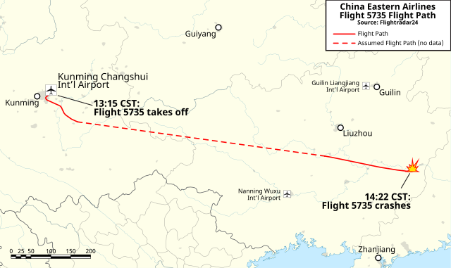
Deutsch: Flugroute des China-Eastern-Airlines-Flugs 5735. English: A map of the flight path for China Eastern Airlines Flight 5735, which crashed in Teng County, Guangxi with 132 people onboard. 日本語: 中国東方航空5735便の飛行経路 中文: 中国东方航空5735号班机飞行路线 |
||
| Date | |||
| Source |
Own work
|
||
| Author | Isochrone | ||
| Other versions |
[]
|
||
| SVG development |


Licensing
Map
I, the copyright holder of this work, hereby publish it under the following license: This file is licensed under the Creative Commons Attribution-Share Alike 4.0 International license.
Flight path
|
File history
Click on a date/time to view the file as it appeared at that time.
| Date/Time | Thumbnail | Dimensions | User | Comment | |
|---|---|---|---|---|---|
| current | 20:09, 21 March 2022 | | 1,588 × 945 (547 KB) | Isochrone | outlines |
| 20:05, 21 March 2022 |  | 1,588 × 945 (402 KB) | Isochrone | =={{int:filedesc}}== {{Information |description={{en|1=A map of the flight path for {{w|Sriwijaya Air Flight 182}}, which crashed into the Java Sea with 62 passengers onboard.}} |date=2022-02-25 |source={{own}} * KML flight data from [https://www.flightradar24.com/blog/china-eastern-airlines-flight-5735-crashes-en-route-to-guangzhou/ Flightradar24]showTrace=2021-01-09&leg=3×tamp=1610167953 here] * Map data from Natural Earth Data * Icons derived from {{f|Maps template-en.svg}}, by {{u|St... |
File usage
The following page uses this file:
Global file usage
The following other wikis use this file:
- Usage on cs.wikipedia.org
- Usage on en.wikipedia.org
- Usage on es.wikipedia.org
- Usage on fi.wikipedia.org
- Usage on fr.wikipedia.org
- Usage on fr.wikinews.org
- Usage on hu.wikipedia.org
- Usage on hy.wikipedia.org
- Usage on id.wikipedia.org
- Usage on it.wikipedia.org
- Usage on ja.wikipedia.org
- Usage on ko.wikipedia.org
- Usage on ms.wikipedia.org
- Usage on nl.wikipedia.org
- Usage on ny.wikipedia.org
- Usage on pl.wikipedia.org
- Usage on pt.wikipedia.org
- Usage on ru.wikipedia.org
- Usage on ta.wikipedia.org
- Usage on th.wikipedia.org
- Usage on uk.wikipedia.org
- Usage on vi.wikipedia.org