File:Afghanistan map.png
No higher resolution available.
Afghanistan_map.png (326 × 350 pixels, file size: 11 KB, MIME type: image/png)
| This free media file is from Wikimedia Commons. Its description page is included below. |

|
This file has been superseded by CIA map of Afghanistan in 2007.gif. It is recommended to use the other file. Please note that deleting superseded images requires consent. Reason to use the other file: "Superseded. Do NOT delete!"
|

|
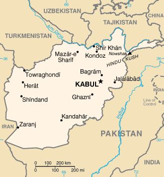
Map of Afghanistan.
[]
UNOCHA Versions
-
 English
 -
 বাংলা
বাংলা -
 español
_-_AFG_-_UNOCHA.svg)
_-_AFG_-_UNOCHA-bn.svg)
_-_AFG_-_UNOCHA-es.svg)
CIA WFB Versions
-
 Original File
 -
 English
 -
 हिन्दी
 -
 中文(臺灣)
 -
 中文
中文 -
 français
 -
 العربية
 -
 čeština


Other English Versions


This image is in the public domain because it contains materials that originally came from the United States Central Intelligence Agency's World Factbook.
|
 |
File history
Click on a date/time to view the file as it appeared at that time.
| Date/Time | Thumbnail | Dimensions | User | Comment | |
|---|---|---|---|---|---|
| current | 16:29, 5 March 2011 | | 326 × 350 (11 KB) | Ras67 | cropped and squeezed |
| 17:39, 17 April 2005 |  | 331 × 355 (21 KB) | Shauni | Map of Afghanistan. This image is a map or flag taken and/or modified from the Central Intelligence Agency's World Factbook. Under United States copyright law, all information and images from the World Factbook are public domain. |
File usage
The following 5 pages use this file:
Global file usage
The following other wikis use this file:
- Usage on ban.wikipedia.org
- Usage on da.wikipedia.org
- Usage on en.wikipedia.org
- Usage on en.wikibooks.org
- Usage on es.wikinews.org
- Usage on fa.wikipedia.org
- کاربر:Artacoana
- کاربر:Sanchooli
- کاربر:Sepehrnoush/nv/mtag
- کاربر:وب پدر
- کاربر:نوید آرین
- کاربر:Ancient relics
- کاربر:علیرضا چوبداری
- کاربر:جعبه کاربر/افغانستان
- کاربر:Erfan Osroes
- کاربر:ERFANINGENIA~fawiki
- کاربر:محک
- کاربر:Sahehco
- کاربر:Torgani
- کاربر:محک/علایقم
- کاربر:Alireza12113
- کاربر:Ebi Mones
- کاربر:Soranikurd
- کاربر:Sam Chalipa
- کاربر:Parspersian1
- کاربر:ر.علامه
- کاربر:Shukayebita
- کاربر:Danial f4
- کاربر:Rashid afghan
- کاربر:راشد عبیدی
- بحث کاربر:Shxahxh
- کاربر:جلیل احمد میرزائی
- کاربر:Amirhosseingholami425
- کاربر:Iri1388
- کاربر:NasrullahSalehS
- کاربر:Sameer.afg
- کاربر:بازی 3
- Usage on fr.wikipedia.org
- Usage on it.wikinews.org
- Usage on ka.wikipedia.org
- Usage on lld.wikipedia.org
- Usage on mi.wikipedia.org
- Usage on sd.wikinews.org